Synopsis:
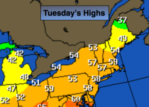
The rollercoaster ride in temperatures will continue. The return flow around an area of high pressure will cause temperatures to spike to near 60º today and the 50s on Wednesday.
An offshore low pressure system will skirt coastal areas late night and early Wednesday with showers.
The getaway day, Wednesday, will feature no travel problems in the Northeast.
Thanksgiving will be colder under mostly sunny skies with highs only in the lower 40s.
No major storms are on the map for the rest of the holiday weekend.
Stay tuned.
Today:
Mostly sunny, much milder. Highs in the upper 50s to around 60º. The average high is 51º. Southwest winds at 10-20mph.
Tonight:
Becoming mostly cloudy with light rain developing late from the I-95 corridor and East. Lows in the 40s in the City the 30s inland. Winds becoming Southwest at 5mph.
Wednesday:
Early morning showers East, otherwise mostly sunny. Highs in the lower 50s.
Thanksgiving:
Mostly sunny. Colder. Highs in the lower to mid 40s.
Friday:
Mostly sunny. Chilly for Black Friday shoppers. Highs in the mid 40s.
Saturday:
Partly sunny, more seasonal. Highs in the lower 50s.
Keep it here for a no nonsense, no hype forecast.