Synopsis:
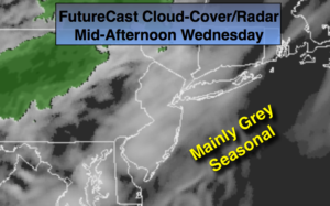
A weak upper level disturbance will result in plenty of clouds for the first day of November. Readings will be seasonal. The average high for the date is 59º.
A warm push is expected tomorrow and Friday as winds turn to the Southwest as high pressure slips offshore. This will be considered Indian Summer for many. Indian Summer is defined as a significant warmup after the first frost or freeze has occurred. Many areas have experienced a freeze or frost outside of urban areas.
The next front will approach Friday night. Cooler conditions are expected this weekend. With Saturday being the better of the two days. Showers are possible Sunday.
Stay tuned.
Today:
Mostly cloudy. Highs in the upper 50s. Northeast to Southeast winds at 5-10mph.
Tonight:
Mainly cloudy. Not as cold as last night. Lows in the mid 50s in the City, the 40s inland. Southeast winds at 5mph.
Thursday:
Clouds to sun. Much Warmer. Highs in the lower 70s.
Friday:
Partly sunny. Warm. Highs around 70º.
Saturday:
Partly sunny, Cooler. Highs in the upper 50s.
Sunday:
Mostly cloudy with scattered showers. Highs in the lower 60s.
Keep it here for a no nonsense, no hype forecast.