Synopsis:
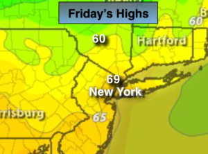
Temperatures will finally return to seasonal levels today. It’s been weeks. It’ll be a nice change for many. The average high is 70º. A Northwest flow will supply the cooler readings.
Fall conditions will be with us this weekend as high pressure works toward the Northeast. A disturbance in the upper atmosphere will spark some showers tonight and then again Saturday afternoon. It won’t be a washout. The sun will dominate Saturday morning and then again on Sunday with readings a few degrees below average for a change.
Today:
Sunny and seasonal. Highs in the 60s inland to around 70º in urban areas. North wind will become Southwest at 5-10mph.
Tonight:
Becoming mostly cloudy with scattered showers developing later in the evening. Lows in the mid 50s in the City, the 40s inland. Southwest winds 5-10mph.
Saturday:
Sun will give way to partly cloudy skies. Scattered showers are possible during the afternoon. Highs in the mid 60s.
Sunday:
Sunny. Highs in the upper 60s.
Monday:
Sunny. Highs in the lower 70s.
Tuesday:
Sunny. Highs in the lower 70s.
Keep it here for a no nonsense, no hype forecast.