Synopsis:
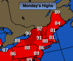
High pressure will continue to influence the Northeast for the start of the workweek. This area of high pressure is large and of warm origin. This resulted in record highs on Sunday with readings in the lower 90s in many areas. The average high for this time of the year is 73º.
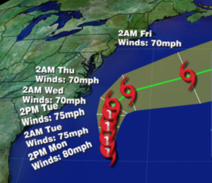
Summer-like readings will stick around through midweek as the strong high pressure moves slowly off the coast. The humidity will be high. At the same time, Hurricane Maria will be moving North up and off the Southeast coast. Maria as of this writing is a category 1 hurricane with winds of 80mph. The storm has weakened considerably. The latest computer guidance has the storm moving due North. This is a result of a strong ridge of high pressure to the North and East of the storm. I am now fairly confident that the storm will move East of the Outer Banks and then take a sharp right hand turn out into the Atlantic. I NEVER let my guard down until a hurricane is North of our latitude. The hurricane should swing off the East coast by Thursday as a cool front moves in. This will finally bring a refreshing airmass down from Canada-yes, feeling more like Fall.
Stay Tuned.
Today:
Mostly sunny, warm and humid. Highs in the mid 80s. Northeast to Southeast winds at 5-10mph.
Tonight:
Partly cloudy and warm. Patchy fog. Lows around 70º in the City, the 60s inland. Southeast winds under 5mph.
Tuesday:
Partly sunny, warm and humid. Highs in the lower to mid 80s.
Wednesday:
Clouds and some sun, humid. Spotty showers possible. Highs around 80º.
Thursday:
Mostly sunny. Much less humid. Highs in the upper 70s.
Friday:
Mostly sunny and cooler. Fall finally makes an appearance. Highs in the lower 70s.
Keep it here for a no nonsense, no hype forecast.