Synopsis:
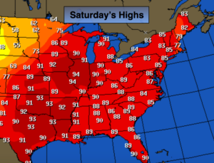
High pressure will build into the Northeast this first weekend of Autumn. This area of high pressure is large and of warm origin. This will result in readings well into the 80s with abundant sunshine. The average high for this time of the year is 73º. Temperatures will flirt with record highs on Sunday. The record for Central Park is 89º. It’ll be close. The humidity will be in check today but will increase some tomorrow.
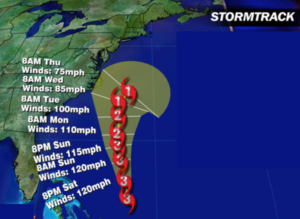
Summer-like readings will stick around through midweek as the strong high pressure moves slowly off the coast. At the same time, Hurricane Maria will be moving North up and off the Southeast coast. Maria as of this writing is a category 3 hurricane with winds of 115mph. The latest computer guidance has pushed the track significantly West. This development is a result of a strong ridge of high pressure to the North and East of the storm. The big question is how fast does the hurricane get to the latitude of the Outer Banks? A trough of low pressure will be swinging in from the Great Lakes later in the week. If the hurricane gets North quick enough it may graze the Mid-Atlantic and Northeast coast before the trough moves in. If it’s slower, the trough will push the hurricane off the North Carolina coast out to sea. At this time it’s a wait and see situation with the out to sea solution a little stronger than up the coast. I NEVER let my guard down until a hurricane is North of our latitude.
Stay Tuned.
Today:
Mostly sunny and very warm. Highs in the mid 80s. North wind at 5-10mph.
Tonight:
Clear and mild. Lows in the lower 70s in the City, the lower 60s inland. North winds under 5mph.
Sunday:
Mostly sunny and hot. Highs in the upper 80s.
Monday:
Mostly sunny and warm. Highs in the mid 80s.
Tuesday:
Mostly sunny and warm. Highs in the mid 80s.
Wednesday:
Partly sunny and warm. Highs in the lower 80s.
Keep it here for a no nonsense, no hype forecast.