Synopsis:
Tropical Storm Jose is well off the Eastern seaboard and moving Northeast with winds of 70mph as of this writing. Rough surf and dangerous rip currents will continue. Gusty winds will diminish overnight.
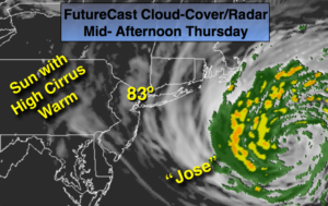
High pressure will build into the Northeast as Jose meanders off the coast. Warm, sunny days are expected as we turn the calendar page from Summer to Fall. In fact, it will be Summer-like right into the weekend. The Autumnal Equinox occurs at 4:02pm Friday. At this exact time, the Sun’s direct rays move South back over the Equator.
Hurricane Maria battered Puerto Rico as a Category 4. Maria has weakened some as it crossed over the island and has now emerged into the Atlantic. As of this writing winds are at 110mph-category 2 status. Extensive damage has occurred in Puerto Rico. The hurricane will continue on it’s Northwest trek and be near the Southeastern Bahamas late week. The latest computer guidance suggests Maria will move North this weekend through the open Atlantic. It is way to soon to speculate if the hurricane will strike the East coast.
Stay Tuned.

Tonight:
Clear to partly cloudy. Lows in the upper 60s in the City, the lower 60s inland. Northwest winds at 8-12mph.
Thursday:
Mostly sunny and warm. Highs in the lower 80s.
Friday:
Mostly sunny and warm. Highs around 80º.
Saturday:
Mostly sunny and warm. Highs in the lower 80s.
Sunday:
Mostly sunny and warm. Highs in the mid 80s.
Monday:
Mostly sunny and warm. Highs in the lower 80s.
Keep it here for a no nonsense, no hype forecast.