Synopsis:
***Tropical Storm Watch for Suffolk County Long Island***
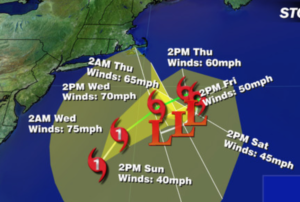
Hurricane Jose is well off the Eastern seaboard and moving North with winds of 75mph as of this writing. The track will take the storm just close enough to the tri-state area for on and off showers and gusty winds tonight. A few downpours are possible in any of the heavier bands of rain that work in from the Atlantic. Winds could gust to 40mph at times at the coast. Minor coastal flooding is also a possibility at the time of high tide. High surf, rip currents and beach erosion is likely.
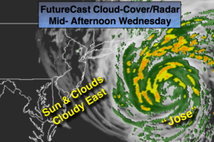
The sun will return for most Wednesday; the exception being Eastern areas. Clouds bands and even a spotty shower is possible as Jose spins offshore.
High pressure will build into the Northeast as the remnants of Jose meander off the coast. Warm, sunny days are expected as we turn the calendar page from Summer to Fall. In fact, it will be Summer-like right into the weekend.
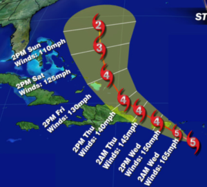
Hurricane Maria continues to strengthen and now is a potentially catastrophic Category 5 with winds of 175mph as of this writing. The Virgin Islands and Puerto Rico are next in line for Maria later tonight and Wednesday which could be a category 5 with winds of 155+mph (map below).
Stay Tuned.
Tonight:
Partly cloudy with scattered showers mainly from I-95 and to the East. A few local downpours are possible. Lows in the upper 60s in the City, the lower 60s inland. North winds at 10-20mph gusting to 40mph at the coast.
Wednesday:
Partly sunny and breezy. Except remaining mainly cloudy over Eastern sections with spotty showers. Highs in the mid 70s to around 80º. North to Northwest winds at 15-25mph.
Thursday:
Mostly sunny and warm. Highs in the lower 80s.
Friday:
Mostly sunny and warm. Highs around 80º.
Saturday:
Mostly sunny and warm. Highs in the lower 80s.
Sunday:
Mostly sunny and warm. Highs in the mid 80s.
Keep it here for a no nonsense, no hype forecast.