Synopsis:
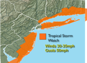
***Tropical Storm Watch for coastal areas Tuesday into Wednesday excluding NYC***
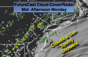
High pressure off the New England coast will cause a Northeast flow off the ocean. This will result in areas of fog and clouds this morning. The fog should burn off and a mix of clouds and sun is expected during the afternoon. Spotty showers can’t be ruled out.
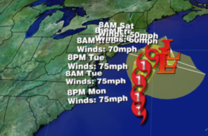
Hurricane Jose is well off the Eastern seaboard and moving North with winds of 75mph as of this writing. Most of the models are in agreement that the hurricane will ride North-parallel and up off the coast through next week (NHC map above, second graphic). The potential of coastal showers and gusty winds are in the forecast for later Tuesday into Wednesday. A Tropical Storm Watch has been posted for coastal areas. Winds may gust between 40-50mph. Coastal flooding is also a possibility. High surf, rip currents and beach erosion is a likely no matter what the eventual track is. If the Jose comes closer to the coast, heavier rain and stronger winds are possible. As we all know, the track can change. Affects from Jose will most likely be felt but at this time a direct hit is slim. As with any tropical system; I NEVER let my guard down until the storm is North of our latitude.
This is the peak of hurricane season. Hurricane Maria continues to strengthen East of the leeward islands and should become a major hurricane as it continues into the Caribbean (map below).
Stay Tuned.

Today:
Morning fog and clouds. The sun will shine from time to time this afternoon. A stray shower is possible. Humid. Highs around in the upper 70s. Northeast winds at 5-10mph.
Tonight:
Mostly cloudy with patchy fog. Scattered showers or areas of drizzle are possible. Lows in the upper 60s in the City, the lower 60s inland. Northeast winds at 10-15mph.
Tuesday:
Mostly cloudy and becoming windy. Showers are possible, especially at the coast. Highs in the mid 70s.
Wednesday:
Mostly cloudy and windy. Showers are possible in the morning, especially at the coast. Highs around in the mid to upper 70s.
Thursday:
Partly sunny and warm. Highs around 80º.
Friday:
Partly sunny and warm. Highs in the mid to upper 70s.
Keep it here for a no nonsense, no hype forecast.