Synopsis:
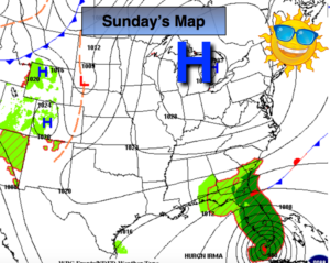
It’ll be a Fall preview through the weekend as a large, cool high pressure system works into the region from Canada. Plenty of sunshine is expected with readings five to eight degrees below average for the highs. There’ll be a nip in the air during the night.
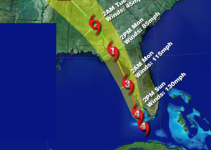
Hurricane Irma is a category 3 hurricane. Winds are sustained at 120mph as of this writing. The storm is moving North and has made landfall in the Florida Keys and now is nearing Naples, Fl.
The storm should continue to move North or North North West along the Southwest Florida coast. It now looks like Irma will either take a track directly on or just off the West coast making landfall somewhere along the Southwest coast of Florida. The hurricane will continue to weaken slowly now as it encounters land and increasing shear. The map below is the National Hurricane Center track. Much can happen to the anticipated track between now and then. A difference of 50 miles could mean the difference between damaging hurricane force winds or gusts just shy of hurricane force. Flooding rains and storm surge will be of great concern.
The hurricane track now looks to take the storm into Georgia. It could be a category 1 hurricane at that time and then become a tropical storm.
Will our area feel any affects from Irma? At this point showers may move up from the remnants midweek.
Stay Tuned.
Today:
Sunny. Highs in the lower 70s. North winds at 5mph.
Tonight:
Clear and very cool. Lows in the upper 50s in the City, the 40s inland. North wind less than 5-10mph.
Monday:
Mostly sunny. Highs in the upper 70s.
Tuesday:
Partly sunny. Highs in the mid to upper 70s.
Wednesday:
Mostly cloudy with scattered showers. Highs in the lower to mid 70s.
Thursday:
More clouds than sun. Highs in the mid 70s.
Keep it here for a no nonsense, no hype forecast.