Synopsis:
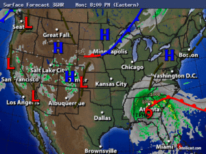
A large high pressure system will dominate our weather for the beginning of the workweek. Skies will be mainly sunny with warm readings through Tuesday. Leftover moisture will work into the area from the remnants of Irma Wednesday through Friday. Clouds will dominate with scattered showers from time to time.
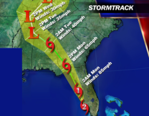
Hurricane Irma made land fall at Marco Island, Florida as a category 3 storm with winds of 115mph. Naples Florida had a wind gust to 142mph late Sunday afternoon. Hurricane Irma at this writing was a Category 2 storm with winds of 105mph.
The storm should continue to move North or North North West along the Southwest Florida coast just inland. The hurricane will continue to weaken slowly now as it encounters land and increasing shear. The map below is the National Hurricane Center track. Flooding rains and storm surge will be of great concern. The threat of tornadoes will continue overnight to the North and East of Irma.
The hurricane track now looks to take the storm into Georgia as a tropical storm by Monday afternoon.
Will our area feel any affects from Irma? At this point showers may move up from the remnants mid to late week.
Stay Tuned.
Tonight:
Clear and very cool. Lows in the upper 50s in the City, the 40s inland. North wind less than 5-10mph.
Monday:
Mostly sunny. Highs in the upper 70s. Winds North at 5mph.
Tuesday:
Partly sunny. Highs in the mid to upper 70s.
Wednesday:
Mostly cloudy with scattered showers. Highs in the lower to mid 70s.
Thursday:
More clouds than sun. Highs in the mid 70s.
Friday:
Mostly cloudy with scattered showers. Highs in the mid 70s.
Keep it here for a no nonsense, no hype forecast.