Synopsis:
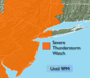
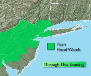
***SEVERE THUNDERSTORM WATCH & FLASH FLOOD WATCH FOR MOST OF THE TRI-STATE AREA THROUGH THIS EVENING***
An active weather day is in anticipated today. The stage will be set for possible severe thunderstorms and torrential rains. Parts of Long Island and coastal NJ will experience flooding rain this morning. A tropical airmass is over the region. It’ll be very uncomfortable with high humidity. During the afternoon a trough of low pressure will bump up against this volatile air mass. This will spark scattered severe thunderstorms. Most of the region is in a slight risk of severe thunderstorms. Keep an eye to the sky for threatening weather after 2PM. Severe thunderstorms contain winds in excess of 58mph and or one inch hail. Since the atmosphere is so moisture laden, torrential rain is possible as well. A Flash Flood Watch is up many areas of NJ. All areas should be aware that flash flooding is possible. 1″3″+ of rain is possible in a short period of time which could lead to flash flooding. If you encounter a flooded roadway- TURN AROUND, DON’T DROWN. The activity should taper off by late evening.
A fine mid-August weekend is on the way. Saturday will feature a mix of sun and clouds as drier air works in from the Northwest. You’ll notice a significant drop in the humidity by mid-day and afternoon. Sunday will be spectacular with abundant sunshine and low humidity. Both days will be very warm.
Weather should not be an issue for viewing the solar eclipse Monday. Hopefully any clouds will be few and far between. Please use caution if you are planning on looking at the eclipse.
Stay Tuned.
Today:
Clouds and hazy sun. Very humid. Scattered showers and possible severe thunderstorms. Torrential rain is possible with any storm. Highs in the lower to mid 80s. South winds at 10-15mph.
Tonight:
Evening scattered thunderstorms, otherwise becoming partly cloudy. Muggy. Lows in the lower 70s in the City, the 60s inland. South to West winds at 5mph.
Saturday:
Sun and clouds. Very warm and becoming less humid. Highs in the upper 80s.
Sunday:
Sunny and very warm. Highs in the upper 80s.
Monday:
Mostly sunny and very warm. Highs in the upper 80s.
Tuesday:
Hazy, very warm and humid. Highs in the upper 80s.
Keep it here for a no nonsense, no hype forecast.