Synopsis:
Typical August conditions will be over the tri-state area through Friday. An area of High pressure off the coast will pump warm and moderately humid air. A weak trough of low pressure will spark spotty showers and storms each afternoon and evening through the end of the week.
A cool front will work in Saturday morning with showers. Sunshine and lowering the humidity is expected by afternoon and Sunday.
Stay tuned.
Tonight:
Spotty storms otherwise party cloudy and muggy. Lows in the lower 70s, the 60s inland. South wind at 5mph.
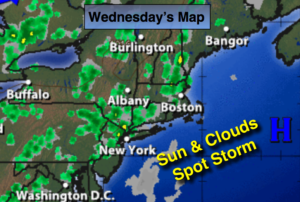
Wednesday:
Hazy, very warm and humid. Spotty PM Storm. Highs in the upper 80s. South winds at 5-10mph.
Thursday:
Hazy and warm. Spotty PM Storms. Highs in the mid 80s.
Friday:
Hazy and warm. Spotty PM Storms. Highs in the mid 80s.
Saturday:
Morning showers, otherwise becoming mostly sunny. Less humid. Highs in the lower 80s.
Sunday:
Mostly sunny. Highs around 80º.
Keep it here for a no nonsense, no hype forecast.