Synopsis:
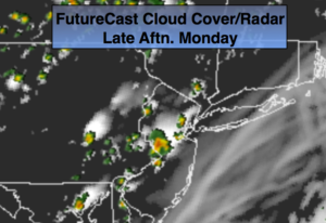
A weak Southerly flow will develop today and continue through mid-week as high pressure remains anchored in the Western Atlantic. This will increase the humidity. A weak trough will be over the region raising the chances of a spotty storm both today and tomorrow.
Much warmer weather will come our way for mid to late week as a bubble of heat works in from the West and South. At this time it doesn’t look like a prolonged period of heat. Most of the models push in a cool front from New England by Friday morning. If this verifies Friday, it’ll still be very warm but with lower humidity.
Stay tuned.
Today:
Mostly sunny, more humid. Spotty PM storms are possible. Highs in the mid 80s. South to Southeast wind at 5mph.
Tonight:
Spotty evening storms otherwise, partly cloudy and muggy. Lows in the lower 70s in the City, the 60s inland. South wind under 5mph.
Tuesday:
Partly sunny, warm and humid. Spotty PM Storms. Highs in the mid 80s.
Wednesday:
Partly sunny, very warm and humid. Highs near 90º.
Thursday:
Hazy, hot and humid. Highs 88º-93º.
Friday:
Mostly sunny, very warm. Highs in the upper 80s to around 90º.
Keep it here for a no nonsense, no hype forecast.