Synopsis:
An onshore flow will persist overnight into early Saturday morning. Areas of Fog, drizzle and spotty showers are likely into Saturday morning. The front will push South and allow for the sun to return later Saturday morning. The afternoon will a winner with warm temperatures and abundant sunshine.
Sunday will be mainly sunny and very warm as weak high pressure works in from the West. The humidity will be at a moderate level this weekend.
A weak Southerly flow will develop for the beginning of the week. Temperatures will be seasonal and a spotty afternoon storm can’t be ruled out.
Much warmer weather will come our way for mid to late week.
Stay tuned.
Tonight:
Cloudy with areas of fog and drizzle. Spotty showers are possible. Lows in the 60s. Southeast winds at 5-10mph.
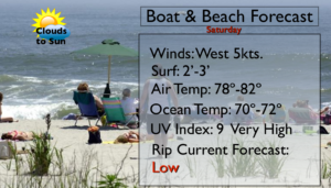
Saturday:
A morning shower East, otherwise becoming mostly sunny. Highs in the lower to mid 80s. Winds becoming West at 5-10mph.
Sunday:
Mostly sunny and warm. Highs in the mid to upper 80s.
Monday:
Partly sunny and warm. Spotty PM Storms. Highs in the mid 80s.
Tuesday:
Partly sunny and warm. Spotty PM Storms. Highs in the mid 80s.
Wednesday:
Partly sunny and very warm. Highs in the upper 80s.
Keep it here for a no nonsense, no hype forecast.