Synopsis:
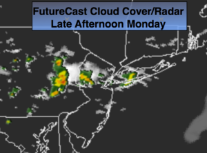
Today will feature sun and clouds with just the chance of a stray late afternoon/evening storm as a trough moves through (FutureCast radar above). Humidity will be low.
Tuesday, the 4 of July will be spectacular with plenty of sunshine and seasonal readings.
If you’re headed to the beach or taking the boat out on the ocean or bay today slather on the sunscreen as the UV index is a very high 10. Please swim in guarded areas.
It’ll be seasonal with a mix of sun and clouds for the midweek period.
Have a fun and safe holiday weekend!
Today:
Partly sunny and very warm. Stray afternoon and evening storms are possible. Highs in the upper 80s. West to Southwest wind at 8-12mph.
Tonight:
A spotty early shower or storm, otherwise, mostly clear. Lows in the upper 60s in the City, near 60º inland. Northwest to North winds at 5mph.
July 4th:
Mostly sunny. Highs in the lower to mid 80s.
Wednesday:
Partly sunny. Highs in the lower 80s.
Thursday:
Sun and clouds. Highs in the lower 80s.
Friday:
Mostly cloudy with scattered showers and thunderstorms. Highs in the mid 80s.
Keep it here for a no nonsense, no hype forecast.