Synopsis:
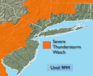
***Severe Thunderstorm Watch is in effect until 9pm for Western areas of the tri-state. Damaging winds and or large hail is possible within this area. Be on the look out for threatening weather. Torrential rain and frequent lightning is likely***
The weather will cooperate for much of the 4 day holiday weekend.
Sunday will be a much better day with mainly sunny skies. It’ll be hot, but the humidity will lower.
Monday will feature sun and clouds with a just the chance of a stray late afternoon/evening storm. Humidity will be low.
Tuesday, the 4 of July will be spectacular with plenty of sunshine and seasonal readings.
If you’re headed to the beach or taking the boat out on the ocean or bay today slather on the sunscreen as the UV index is a very high 10. The water will be rough and there’s a moderate to high chance of rip currents. Please swim in guarded areas.
Have a fun and safe holiday weekend!
Today:.
Hazy, warm and humid. Scattered afternoon and evening storms. Highs in the mid 80s, cooler at the coast. Southwest winds at 10-20mph.
Tonight:
An evening shower or storm otherwise, partly cloudy, warm and muggy. Lows in the mid 70s in the City, the 60’s to around 70º inland. Southwest to West winds at 8-12mph.
Sunday:
Mostly sunny, hot and becoming less humid. Highs near 90º.
Monday:
Sun and clouds. A stray afternoon storm is possible. Most areas will be rain-free. Highs in the mid 80s.
July 4th (Tuesday):
Mostly sunn. Highs in the mid 80s.
Wednesday:
Partly sunny. Highs in the mid 80s.
Keep it here for a no nonsense, no hype forecast.