Synopsis:
A very warm and humid airmass will over the region through Saturday morning. A cool front will approach the region along with a weak disturbance. Showers and thunderstorms are possible tonight and Saturday morning. Some of the rainfall could be heavy.
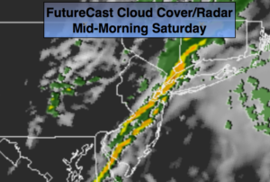
The weekend will start off damp but improving conditions are rapidly expected. Scattered showers and storms will end from West to East during the morning hours. The second half of Saturday will feature sunshine and lowering humidity. Sunday will be a gem with plenty of sunshine and low humidity.
Stay tuned.
Tonight:
Scattered showers and thunderstorms. Muggy. Lows 70º-75º. South/Southwest winds at 8-12mph.
Saturday:
Scattered showers and thunderstorms will end between 8am and Mid-day from West to East. The sun will return soon after. The humidity will decrease. Highs in the mid 80s. West winds at 10-15mph.
Sunday:
Mostly sunny. Highs in the lower 80s.
Monday:
Partly sunny. Highs in the upper 70s.
Tuesday:
Sun and clouds. Spotty showers. Highs in the mid to upper 70s.
Wednesday:
Mostly sunny. Highs in the lower 80s.
Keep it here for a no nonsense, no hype forecast.