Synopsis:
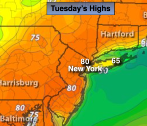
It’ll feel like mid-June today as the core of the warm air works in from the South and West. As is typical this time of the year, the coast will be significantly cooler with a flow off the cold atlantic. There will be a large difference in temperature within a few miles of the coast.
A cool front will push through tomorrow with a few spotty showers, it will not be a washout in fact much of the time will be dry. Temperatures will come down in steps by the end of the week and be close to seasonal averages. At this time, it looks like the weather will cooperate for the Easter Holiday weekend.
Today:
Mostly sunny and warm. Highs around or just over 80º. Much cooler at the shore. South Southwest wind at 10-20mph.
Tonight:
Partly cloudy and very mild. Temperatures will be warmer then the average high for the date! Lows in the lower 60s in the City, the 50s inland. Light South Southwest wind.
Wednesday:
Sun and clouds, mild. Spotty showers. Highs around 70º.
Thursday:
Partly sunny, cooler. Highs around 60º.
Friday:
Partly sunny and seasonal. Highs in the lower 60s.
Saturday:
Partly sunny. Highs in the lower 60s.
Keep it here for a no nonsense, no hype forecast.