Synopsis:
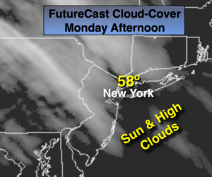
The workweek will start off tranquil with sun giving way to clouds today.
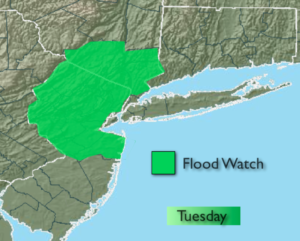
The pattern is very active with two storms on the horizon for Tuesday and Thursday. With both systems there is a potential for moderate to heavy rainfall. Flooding may become an issue. A Flood Watch has been posted for storm #1 on Tuesday for much of Northern and Central NJ and areas just North of the City. The ground is saturated from recent snowmelt and heavy rain. Any additional heavy rain may cause flooding of streams and creeks and possible minor flooding of some main stem rivers. The rain will begin later this evening and come down heavy at times tonight and Tuesday morning. 1″-2″ of rain is possible.
There will be a brief break in the rain on Wednesday as the sun returns. Storm #2 will move in Thursday with more rain.
Stay Tuned.
Today:
Partly sunny. Highs in the upper 50s to lower 60s. East to Southeast wind at 8-12mph.
Tonight:
Rain developing within a few hours of Midnight. The rain will be heavy at times late. Southeast winds at 10-20mph with higher gusts late.
Tuesday:
Periods of rain. Highs in the lower 60s.
Wednesday:
Partly sunny. Highs around 60º.
Thursday:
Rain Likely. Highs in the upper 50s.
Friday:
Mostly cloudy, cooler. Highs in the lower 50s.
Keep it here for a no nonsense, no hype forecast.