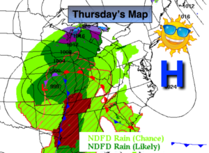
Synopsis:
High pressure will dominate our weather through today. This will result in sunshine giving way to afternoon clouds.
The break from the rain will be brief as another round is expected Friday and into the first part of Saturday as a storm forms along the East coast. Rain is likely. The rain could be heavy at times. A mix or wet snow could fall over the higher elevations well North of the City Friday Night.
Sunday will be the better half of the weekend.
Stay Tuned.
Today:
Mostly sunny. Clouds will roll in during the afternoon. Highs in the lower 50s. North wind will become Southeast at 5mph.
Tonight:
Thickening clouds with light rain developing around midnight . Lows in the upper 30s in the City, the mid inland. Southeast wind at 5-10mph.
Friday:
Cloudy with periods of rain. Some sleet or wet snow is possible over the higher elevations to the North of the City. Highs in the 40s, 30s inland.
Saturday:
Rain likely during the morning. The sun should return by afternoon. Highs around 50º.
Sunday:
Mostly sunny. Highs in the mid 50s.
Monday:
Mostly sunny. Highs in the mid 50s.
Stay Tuned.
Keep it here for a no nonsense, no hype forecast.