Synopsis:.
The weekend will be a 50/50 Split, with today being the better of the two days.
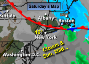
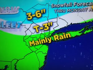
Today will be dry under mostly cloudy skies with milder readings as we’ll be in between two systems. A low will move in on Sunday with rain developing in the morning. North and West a mix snow and sleet is likely with some accumulation possible (expected snow amounts above).
The storm will intensify rapidly over New England and result in very strong winds on Monday for the region. Gusts to 50mph are possible.
Looking down the pike we need to keep our eye on a Southern low. Will the storm come up the coast or go harmlessly out to sea? There is cold air available. Stay tuned.
Today:
Mostly cloudy and mild. Highs in the mid 40s. West wind at 5-10mph.
Tonight:
Thickening clouds. Lows in the mid to upper 30s in the City, around 30º inland. North to Northeast wind at 5-10mph.
Sunday:
Rain developing. A mix of snow and sleet is likely North and West. Highs in the around 40º.
Monday:
Partly sunny, windy. Highs around 40º.
Tuesday:
Partly sunny. Highs in the lower 40s.
Wednesday:
Clouds and sun. Highs in the lower 40s.
Stay Tuned.
Keep it here for a no nonsense, no hype forecast.