Synopsis:.
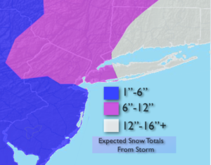
A Blizzard Warning is in effect for Long Island & Southeastern Connecticut through this afternoon. This region will experience the highest winds and heaviest snow making for a blizzard. Snow will continue heavy at times over parts of Long Island and coastal Connecticut through this afternoon. Snowfall rates of 1″-3″/hr are possible in spots. Elsewhere snow will taper off and end. Clouds and some sun is expected first over Northwestern regions than closer to the City later today. Considerable blowing and drifting of the snow is expected. Snow amounts are posted above.
High pressure will work in for Friday. Tranquil conditions are expected.
Rapidly moving weak areas of low pressure will work through this weekend. The first Friday night-snow showers are possible. The second on Sunday with rain showers.
Rest of Today:
Snow over Eastern areas. Clouds and sun West. Windy. Temperatures falling into the 20s. North to Northwest wind at 15-35mph with gusts to 45mph.
Tonight:
Becoming mostly clear. Lows in the teens throughout. Northwest to North wind at 15-30mph and diminishing. Blowing and drifting snow.
Friday:
Partly sunny and cold with highs around 30º.
Saturday:
Mostly cloudy and mild. Highs in the mid 40s.
Sunday:
Cloudy. Scattered showers. Highs in the mid 40s.
Monday:
Partly sunny. Highs in the lower 40s.
Tuesday:
Partly sunny. Highs in the lower 40s.
Stay Tuned.
Keep it here for a no nonsense, no hype forecast.