Synopsis:.
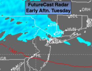
A weak, fasting moving Alberta Clipper will move though the region today. Snow showers are expected to develop mid to late morning and continue on and off until sunset. A period of light steady snow can’t be ruled out. The Northern 1/2 of the tri-state area has the best chance of seeing the flakes fly. To the South of the City mostly cloudy skies are expected (FutureCast Radar above). A coating of snow is possible in and around the City. Up to two inches is possible North of the City.
As we welcome in February it looks tranquil with a trend to colder but with dry conditions.
The next threat and its only that- a threat, is the February 5th-6th time frame. The models are not agreeing with this system later Superbowl Sunday. The potential exists for some snow. Stay tuned.
Today:
Cloudy with periods of light snow or snow showers developing mid to late morning . Little to no snow is expected to the South of the City. A minor accumulation is possible by evening where the snow does fall. Highs in the upper 30s. Southeast to West wind at 5-10mph.
Tonight:
Snow showers ending this evening over Eastern areas, otherwise partly cloudy. Lows in the lower to mid 30s in the City, the 20s inland. Winds becoming West late at 10-15mph.
Wednesday:
Partly sunny, mild. Highs in the mid 40s.
Thursday:
Partly sunny, colder. Highs in the mid 30s.
Friday:
Partly sunny, colder yet. Highs in the lower 30s.
Saturday:
Partly sunny. Highs around freezing.
Stay Tuned.
Keep it here for a no nonsense, no hype forecast.