Synopsis:
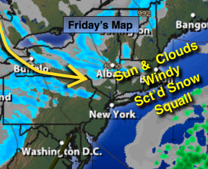
An intense storm over Eastern Canada will cause gusty winds in our area today. A mix of sun and clouds is expected. The atmosphere will be unstable and lake effect snow streamers may make it down to the trip-state area. These snow squalls will be isolated, but if you are in its path a brief period of heavy snow and high winds will occur. Again, many areas will just be windy under partly sunny skies.
New Year’s weekend will be tranquil weather wise with temperatures in the lower 40s with a mix of sun and clouds.
Periods of rain and drizzle are expected for the beginning of the week along with mild readings.
Looking down the pike much colder temperatures are anticipated and an area of low pressure may form along the East coast later next week or into next weekend. Could this be our first real threat? Stay tuned.
Today:
Partly sunny, windy, colder with isolated snow squalls. Highs in the upper 30s to lower 40s. West wind at 15-30mph.
Tonight:
Scattered evening flurries otherwise partly cloudy and breezy. Lows in the upper 20s in the City, around 20º inland. West winds at 15-25mph and diminishing.
Saturday:
Partly sunny. Seasonal. Highs around 40º.
Sunday (New Year’s Day):
Partly sunny. Highs in the mid 40s.
Monday:
Mostly cloudy with periods of light rain or drizzle. Highs in the mid 40s.
Tuesday:
Rain is likely. Mild with readings in the lower 50s.
Stay Tuned.
Keep it here for a no nonsense, no hype forecast.