Synopsis:
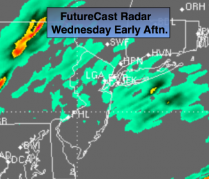
A large low pressure system will continue to intensify over the Northern Plains through today. Areas of dense fog will be will slow travel this morning. A cool front will approach later today for November’s finale, with the second shot of rain. This rain will be scattered and then become steadier and heavier later today and into early tonight(FutureCast radar above). The one, two punch of rain will amount to total rainfall of one to three inches. This will help the drought situation. Highs today will be reach the lower 60s. The highs will occur early tonight. Skies will finally clear out for December’s debut on Thursday. It won’t feel like December though. Readings will be well into the 50s. Snow lovers you’re going to have to wait. Looking down the pike it looks it does get colder. My eyes are on a potential low pressure system that may affect the area Monday or Tuesday of next week. Lets see how the elements come together over the next couple of days. The chances of any snow are minimal at this time. Stay tuned.
Today:
Scattered showers this morning with areas of dense fog. Steadier and heavier rain developing later today. Balmy. Highs in the lower 60s. Northeast to Southeast wind at 5-10mph.
Tonight:
Rain, possibly heavy at times with a chance of thunderstorms. Very Mild. Lows in the 50s in the City, the 40s inland. Southeast wind becoming West at 10-15mph.
Thursday:
Becoming partly sunny. Still mild. Highs in the mid to upper 50s.
Friday:
Partly sunny, cooler. Highs in the upper 40s.
Saturday:
Partly sunny, more seasonal. Highs in the mid to upper 40s.
Sunday:
Partly sunny, cool. Highs in the mid 40s.
Stay Tuned.
Keep it here for a no nonsense, no hype forecast.