Synopsis:
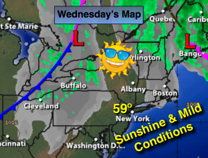
A warm stretch is on the way for today through Saturday. It will not feel like mid November as high pressure builds over the East coast with the lack of any cold air. Highs will be five to ten degrees above average.
An energized trough will develop along the East coast by Sunday. This will most likely bring down some of the coldest air this season so far and possible some snow showers.
Today:
Mostly sunny. Highs in the upper 50s. West winds at 8-12mph.
Tonight:
Partly cloudy. Lows in the upper 40s in the City, around 40º inland. Northwest wind at 5-10mph.
Thursday:
Sunny with readings near 60º.
Friday:
Sunny and warm with highs in the mid 60s.
Saturday:
Partly sunny with readings in the lower to mid 60s.
Sunday:
More clouds than sun, windy and much colder. Scattered snow showers are possible. Highs will start off the in the upper 40s and fall throughout the day.
Stay Tuned.
Keep it here for a no nonsense, no hype forecast.