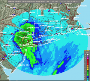
Synopsis:
The area of low pressure that gave some regions heavy rainfall this morning and afternoon will continue to move up along the coast (Rainfall amounts are posted above, some parts of Monmouth county and Northeastern NJ received over two inches). Rain will taper off from the City and to the South and West. Some sunshine is possible over Southern and Western areas and possibly by the coast later today. Tranquil conditions will return mid to late week with above average readings.
An energized trough will develop along the East coast by Sunday. This will most likely bring down some of the coldest air this season so far and possible some snow showers.
Tonight:
Any evening showers will end by the coast, otherwise becoming partly cloudy. Lows in the mid 40s in the City, the 30s inland. Northwest wind at 5-10mph.
Wednesday:
Partly sunny. Highs in the upper 50s.
Thursday:
Sunny with readings near 60º.
Friday:
Sunny and warm with highs in the mid 60s.
Saturday:
Partly sunny with readings in the lower to mid 60s.
Sunday:
More clouds than sun, windy and much colder. Scattered snow showers are possible. Highs will start off the in the upper 40s and fall throughout the day.
Stay Tuned.
Keep it here for a no nonsense, no hype forecast.