Synopsis:
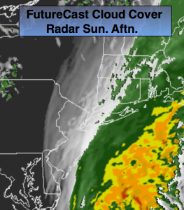
The combination of Post-Cyclone Matthew moving off the Outer Banks of North Carolina and a cool front along the coast will result in an area of rain that will mainly cover the I-95 corridor Southeast to the coast today. It’ll rain in these areas through the morning. North and West it’ll be cloudy but mainly dry. As the storm and front continue to move East the rain will taper off from West to East this afternoon (FutureCast Cloud Cover & Radar above). The skies will brighten and the sun will return inland. It’ll be windy with strong high pressure moving into the Great Lakes and the departing storm.
A dry stretch is in the making for the majority of next week with high pressure reigning supreme. It’ll be sunny and cooler than average to start the week.
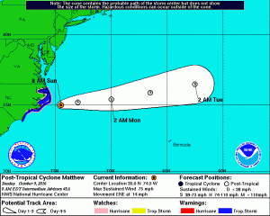
Hurricane Matthew has lost it’s characteristics and is now post-tropical and moving off the Outer Banks of North Carolina. Record rain fell in North Carolina and winds did gust above hurricane force at the coast. The storm will continue to weaken and move out to sea.
Today:
Rain along the coast this morning. Cloudy inland. The rain will taper off from West to East this afternoon at the coast. Increasing sunshine is expected inland. Windy. North wind at 15-30mph with gusts to 40 at the coast. Highs in the lower 60s.
Tonight:
Becoming mostly clear. Breezy and much cooler. Lows in the upper 40s in the City, the lower 40s inland. North wind at 15-25mh.
Monday:
Mostly sunny, breezy and cool. Highs in the lower 60s. The average high is 66º.
Tuesday:
Sunny with readings in the lower to mid 60s.
Wednesday:
Sunny and seasonal with readings in the mid 60s.
Thursday:
Partly Sunny with highs in the upper 60s.
Stay Tuned.
Keep it here for a no nonsense, no hype forecast.