Synopsis:
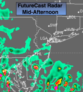
An area of low pressure will drop out of the Great Lakes and move to the Mid-Atantic and stall for two days. Strong high pressure will be over Northern New England. The combination of these systems will result in on and off showers today into the weekend. At this time it looks as though the steadiest and heaviest rain will stay out of our area (FutureCast radar above for this Afternoon). Cool and breezy conditions are expected through the end of the week.
Slow improvement will occur this weekend. Saturday will be mostly cloudy with stray showers or areas of drizzle. Sunday will be the better half of the weekend with more sunshine but still the threat of a showers.
Today:
Cloudy, breezy and cool with on and off showers and areas of drizzle. Highs in the mid 60s. Northeast winds at 15-25mph.
Tonight:
Cloudy with drizzle and scattered showers. Lows in the 50s. Northeast wind at 10-20mph.
Friday:
Cloudy, breezy and cool with on and off showers and areas of drizzle. Highs in the mid 60s.
Saturday:
Mostly cloudy with spotty showers possible. Highs in the upper 60s.
Sunday:
Partly sunny a shower can’t be ruled out, warmer with highs in the lower 70s.
Monday:
Partly sunny and warm with highs in the mid 70s.
Tropical Storm Matthew will continue to move through the Caribbean. After that it should turn North and be near Eastern Cuba early next week. It is way to early to forecast if this storm will affect the Eastern Seaboard. Those who are claiming it will are not a reliable source.
Stay Tuned.
Keep it here for a no nonsense, no hype forecast.