Fine Start to the Week…


Synopsis:

High pressure moving off the Mid-Atlantic coast will be responsible for our magnificent Monday. Sun-filled skies and warm readings are expected. Temperatures will be a few degrees above the average high of 77º.

Tonight will be clear and comfortable. Great sleeping conditions!

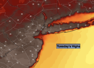
Tuesday will start with sun but clouds will roll in during the afternoon.

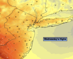
A weak front will move through the region Wednesday with morning showers. The sun should return during the afternoon.

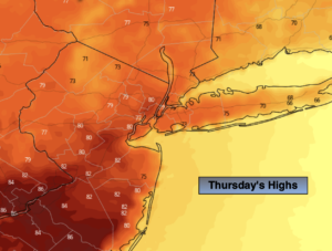
A period of rain and possibly a thunderstorm is in the forecast for Wednesday night into Thursday morning as low pressure moves swiftly through the region from the Southwest. The sun should return during the afternoon Thursday.

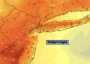
Friday will feature high pressure building into the region. Plenty of sunshine and warm readings are anticipated.

Stay tuned.

Keep it here for a no hype, no nonsense forecast.

Monday:

Sunny. Warm Highs around 80º. South winds at 5-10mph.

Tonight:

Clear. Lows in the lower to mid 60s in the City, the 50s inland. Southwest winds at 5mph.

Tuesday:

Morning sun, afternoon clouds. Highs in the mid to upper 70s.

Wednesday:

Scattered showers during the morning giving way to a party sunny afternoon. Highs in the mid to upper 70s.

Thursday:

A chance of rain and thunderstorms during the morning. Some afternoon sun. Highs around 80º.

Friday:

Mostly sunny. Highs around 80º.


Catch me on the Fox Weather Stream from 10am-2pm Friday. Find us on Tubi, Roku TV and YouTube TV and as always the Fox Weather App. It’s Free!

Spectacular Weekend…


Synopsis:

The first weekend of June will spectacular as high pressure dominates. Both days will feature abundant sunshine with readings near of just above the seasonal highs of the mid to upper 70s. Night will be cool and dry.

The fine conditions will continue into Monday.

Any sun on Tuesday will give way to afternoon showers as a front moves into the region.

Scattered showers are likely on Wednesday as the front slows down over the region.

Stay tuned.

Keep it here for a no hype, no nonsense forecast.

Saturday:

Sunny. Highs in around 80º. West winds at 5-10mph.

Tonight:

Clear and cool. Lows in the upper 50s in the City, the 40s to around 50º inland. Northwest winds at 5mph.

Sunday:

Sunny. Highs in the mid to upper 70s.

Monday:

Mostly sunny. Highs in the mid 70s.

Tuesday:

Morning sun to late afternoon showers. Highs in the mid to upper 70s.

Wednesday:

Mostly cloudy with scattered showers. Highs around 80º.


Catch me on the Fox Weather Stream from 10am-2pm Friday. Find us on Tubi, Roku TV and YouTube TV and as always the Fox Weather App. It’s Free!

Clouds to Sun. A Fine Friday…


Synopsis:

Friday will be decent as the cool front moves off the coast. Any clouds (and an early morning shower in spots) will give way to sunny skies. It’ll be much less humid and a fine day is on tap.

Tonight we’ll have fine sleeping weather as readings will fall to cool levels.

The first weekend of June will spectacular as high pressure dominates. Both days will feature abundant sunshine with readings near of just above the seasonal highs of the mid to upper 70s.

The fine conditions will continue into Monday.

Any sun on Tuesday will give way to afternoon showers as a front moves into the region.

Stay tuned.

Keep it here for a no hype, no nonsense forecast.

Friday:

An early morning shower in spots, otherwise clouds will give way to sun. Highs in the mid to upper 70s. Northeast to North winds at 5-10mph.

Tonight:

Clear and cool. Lows in the lower 60s in the City, around 50º well inland. Northwest winds at 5mph.

Saturday:

Sunny. Highs in the mid to upper 70s.

Sunday:

Sunny. Highs in the mid to upper 70s.

Monday:

Mostly sunny. Highs in the mid 70s.

Tuesday:

Morning sun to afternoon showers. Highs in the mid 70s.

Catch me on the Fox Weather Stream from 10am-2pm Friday. Find us on Tubi, Roku TV and YouTube TV and as always the Fox Weather App. It’s Free!

Sct’d Storms Early Tonight. A Fine Friday…


Synopsis:

Scattered storms are likely through early tonight with an approaching cool front. A Severe Thunderstorm Watch is in effect for Mercer, Monmouth and Ocean counties until 9PM. Keep an eye to the sky for threatening weather.

Friday will be decent as the cool front moves off the coast. Any clouds will give way to sunny skies. It’ll be much less humid and a fine day is on tap.

The first weekend of June will spectacular as high pressure dominates. Both days will feature abundant sunshine with readings near of just above the seasonal highs of the mid to upper 70s.

The fine conditions will continue into Monday.

Any sun on Tuesday will give way to afternoon showers as a front moves into the region.

Stay tuned.

Keep it here for a no hype, no nonsense forecast.

Tonight:

Scattered showers and thunderstorms. Lows in the lower 60s throughout. East winds at 5mph.

Friday:

Clouds to sun. Highs in the mid to upper 70s. Northeast to North winds at 5-10mph.

Saturday:

Sunny. Highs in the mid to upper 70s.

Sunday:

Sunny. Highs in the mid to upper 70s.

Monday:

Mostly sunny. Highs in the mid 70s.

Tuesday:

Morning sun to afternoon showers. Highs in the mid 70s.


Catch me on the Fox Weather Stream from 10am-1pm Wednesday. Find us on Tubi, Roku TV and YouTube TV and as always the Fox Weather App. It’s Free!

Warmer Thursday. Clouds & Sun. PM Rumble…


Synopsis:

Thursday will be a battle between the clouds and sun. It’ll be warmer than yesterday. Readings in many areas will reach 80º with a wind off the land for a time. Another round of scattered storms will develop later this afternoon with an approaching cool front. Scattered showers and storms are likely tonight with the passage of the front.

Friday will be decent as the system moves off the coast. Any clouds will give way to sunny skies.

The first weekend of June will spectacular as high pressure dominates. Both days will feature abundant sunshine with readings near of just above the seasonal highs of the mid to upper 70s.

The fine conditions will continue into Monday.

Stay tuned.

Keep it here for a no hype, no nonsense forecast.

Thursday:

Clouds and sun. Much warmer. Late day scattered storms possible. Highs around 80º. Cooler at the coast. Southwest to Northwest winds at 5-10mph.

Tonight:

Scattered showers and thunderstorms. Lows in the lower 60s throughout. East winds at 5mph.

Friday:

Clouds to sun. Highs in the mid to upper 70s.

Saturday:

Sunny. Highs in the mid to upper 70s.

Sunday:

Sunny. Highs in the mid to upper 70s.

Monday:

Mostly sunny. Highs in the mid 70s.

Catch me on the Fox Weather Stream from 10am-1pm Wednesday. Find us on Tubi, Roku TV and YouTube TV and as always the Fox Weather App. It’s Free!

Sct’d Storms Tonight. Warmer Thursday. PM Rumble…


Synopsis:

Two disturbances will ride rapidly through our region tonight and then again on Thursday afternoon and night. Scattered showers and storms are possible during these times. Some of the storms maybe strong to severe North and West tonight.

During the day on Thursday partly sunny skies are expected with a pop in temps. Readings in many areas will reach 80º or above. Once again it’ll be cooler by the coast.

Friday will be decent as the system moves off the coast. Any clouds will give way to sunny skies.

The first weekend of June will spectacular as high pressure dominates. Both days will feature abundant sunshine with readings near of just above the seasonal highs of the mid to upper 70s.

The fine conditions will continue into Monday.

Stay tuned.

Keep it here for a no hype, no nonsense forecast.

Tonight:

Scattered showers and thunderstorms. Some of the storm inland maybe strong to severe. Lows in the lower 60s in the City around 60º inland. Light South winds.

Thursday:

Sun and clouds. Much warmer. Late day scattered storms possible. Highs around 80º. Cooler at the coast.

Friday:

Clouds to sun. Highs in the mid to upper 70s.

Saturday:

Sunny. Highs in the mid to upper 70s.

Sunday:

Sunny. Highs in the mid to upper 70s.

Monday:

Mostly sunny. Highs in the mid 70s.

Catch me on the Fox Weather Stream from 10am-1pm Wednesday. Find us on Tubi, Roku TV and YouTube TV and as always the Fox Weather App. It’s Free!

Much Cooler Wednesday…


Synopsis:

June’s debut on Wednesday will feature a mix of clouds and some sun. Readings will be twenty five degrees cooler than Tuesday’s 90s with a wind off the cooler Atlantic. Readings will be cooler than the City to the East and much warmer to the West.

Two disturbances will ride rapidly through our region tonight and then again on Thursday afternoon and night. Scattered showers and storms are possible during these times. During the day on Thursday partly sunny skies are expected with a pop in temps. Readings in many areas will reach 80º or above. Once again it’ll be cooler by the coast.

Friday will be decent as the system moves off the coast. Any clouds will give way to sunny skies.

The first weekend of June will spectacular as high pressure dominates. Both days will feature abundant sunshine with readings near of just above the seasonal highs of the mid to upper 70s.

Stay tuned.

Keep it here for a no hype, no nonsense forecast.

Wednesday:

Clouds and sun. Much cooler. Highs in the upper 60s in the City, much warmer to the West, cooler to the East. East to Southeast winds at 5-10mph.

Tonight:

Scattered showers and a slight chance of a thunderstorm. Lows in the lower 60s in the City around 60º inland. Light South winds.

Thursday:

Sun and clouds. Much warmer. Late day scattered storms possible. Highs around 80º. Cooler at the coast.

Friday:

Clouds to sun. Highs in the mid to upper 70s.

Saturday:

Sunny. Highs in the mid to upper 70s.

Sunday:

Sunny. Highs in the mid to upper 70s.

Catch me on the Fox Weather Stream from 10am-1pm Wednesday. Find us on Tubi, Roku TV and YouTube TV and as always the Fox Weather App. It’s Free!

Toasty Tuesday. Hottest Day of the Year So Far…


Synopsis:

Today will be the hottest day of the year so far. Readings will soar into the lower to mid 90s as we close out the month of May. The record high for Central Park is 96º set in 1939. That record should remain for at least one more year. The bubble of hot air around a Bermuda high is responsible for our mid-Summer feel.

A back door cold front will move into our area tonight from New England. This will put an end to our brief bout with Summer. Spotty showers are possible overnight.

June’s debut on Wednesday will feature a mix of clouds and some sun. Readings will be more seasonable with a wind off the cooler Atlantic. It’ll be much cooler to the east and warmer inland.

Two disturbances will ride rapidly through our region Wednesday Night and then again on Thursday night. Scattered showers and storms are possible during these times. During the day on Thursday partly sunny skies are expected.

Friday will be decent as the system moves off the coast. Any clouds will give way to sunny skies.

The start of the first weekend of June will spectacular as high pressure dominates. Saturday highs will be just above the seasonable averages of the mid 70s.

Stay tuned.

Keep it here for a no hype, no nonsense forecast.

Tuesday:

Hazy and hot. Highs in the lower to mid 90s. West to Northwest winds at 8-12mph.

Tonight:

Mostly cloudy. Spotty showers possible. Lows in the lower to mid 60s throughout. Northeast winds at 5mph.

Wednesday:

Clouds and sun. More seasonable. Highs in the mid 70s in the City, much warmer to the West, cooler to the East.

Thursday:

Sun and clouds. Late day scattered storms possible. Highs in the mid to upper 70s.

Friday:

Clouds to sun. Highs in the upper 70s.

Saturday:

Sunny. Highs in the upper 70s.

Catch me on the Fox Business Network from 6am-9am this weekend and on the Weather Stream until Noon. Find us on Tubi, Roku TV and YouTube TV and as always the Fox Weather App. It’s Free!

A Sunday Winner…


Synopsis:

Sunday and Memorial Day will be winners!  It’ll be bright with moderating temperatures as high pressure builds over the region. Today readings will be about five degrees above average. The holiday will have a Summer feel with readings at least ten degrees above the average high of 75º.

Hazy, hot and humid conditions will be with us on Tuesday as we close out the month of May.

June’s debut on Wednesday will feature bright and more seasonable readings as the winds turns to the East off the cooler Atlantic. It’ll be warmer inland.

A mix of sun and clouds is expected for Thursday. Showers are possible as a disturbance moves in .

Stay tuned.

Keep it here for a no hype, no nonsense forecast.

Sunday:

Sunny. Highs around 80º. Cooler at the coast. Northeast to South winds at 5-10mph.

Tonight:

Clear. Lows in the mid 60s in urban areas, the 50s inland. South to Southwest winds less than 5mph.

Memorial Day:

Sunny. Very warm. Highs in the upper 80s.

Tuesday:

Hazy, hot and humid. Highs in the lower 90s.

Wednesday:

Sun and clouds. More seasonable. Highs in the mid 70s in the City, much warmer to the West, cooler to the East.

Thursday:

Sun and clouds with a chance of showers. Highs in the mid to upper 70s.

Catch me on the Fox Business Network from 6am-9am this weekend and on the Weather Stream until Noon. Find us on Tubi, Roku TV and YouTube TV and as always the Fox Weather App. It’s Free!

Sct’d Showers Saturday. Aftn. Storm. Seasonable.


Synopsis:

An upper level trough will move into and through the area by this afternoon. Until these features pass the region scattered showers are thunderstorms area possible. It will not be a washout today. It will be seasonable with highs in the mid 70s.  The sun may shine later in the day.

Sunday and Memorial Day will be winners!  It’ll be bright with moderating temperatures as high pressure builds over the region. The holiday will have a Summer feel with readings at least ten degrees above the average high of 75º. 2 out of 3 for the Memorial Day weekend ain’t bad!

Hazy, hot and humid conditions will be with us on Tuesday as we close out the month of May.

June’s debut will feature bright, warm conditions.

Stay tuned.

Keep it here for a no hype, no nonsense forecast.

Saturday:

Clouds, some sun. Scattered showers and possible a thunderstorm during the afternoon. It will not be a washout. Highs in the mid 70s. Southwest to Northwest winds at 5-10mph.

Tonight:

Mostly clear. Lows in the low 60s in urban areas, the 50s inland. Northwest winds at 5mph.

Sunday:

Sunny. Highs around 80º.

Memorial Day:

Sunny. Very warm. Highs in the upper 80s.

Tuesday:

Hazy, hot and humid. Highs in the lower 90s.

Wednesday:

Sun and clouds. Warm. Highs in the lower to mid 80s.

Catch me on the Fox Business Network from 6am-9am this weekend and on the Weather Stream until Noon. Find us on Tubi, Roku TV and YouTube TV and as always the Fox Weather App. It’s Free!