Synopsis:
An Autumn chill has settled in and will be with us through the end of the week as Canadian high pressure dominates. The sun will rule the sky through Saturday. Readings will be below the average high of the upper 60s through the end of the week.
A frost advisory is in effect tonight for the most of NJ.
A mild push will send readings several degrees above average on Saturday.
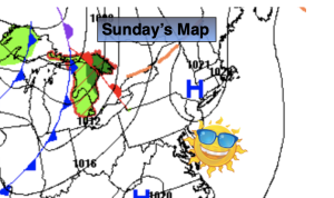
Sunday will start off bright, but a cold front will approach for the afternoon with more clouds and possible scattered showers.
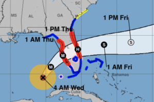
Milton is off the East coast of Florida and moving out to sea.
Stay tuned.
Keep it here for a no nonsense, no hype forecast.
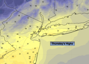
Thursday:
Mostly sunny, breezy and quite cool. Highs around 60º. Northwest winds at 10-20mph.
Tonight:
Clear. Chilly. Lows in the mid to upper 40s in the City, the 30s inland with scattered frost. Northwest winds diminishing to 5mph.
Friday:
Sunny. Highs in the mid to upper 60s.
Saturday:
Mostly sunny. Mild. Highs in the lower to mid 70s.
Sunday:
Sun and clouds. PM shower possible. Highs in the upper 60s.
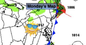
Monday:
Partly sunny. Cooler. Highs in the lower to mid 60s.