Synopsis:
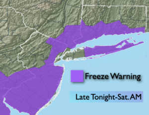
A freeze is expected for many areas outside of NYC tonight as cold air works in from Canada under clearing skies.
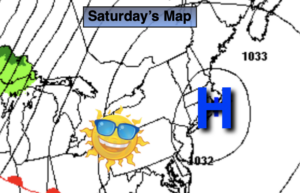
On Halloween cold high pressure will settle over the region. Abundant sunshine is expected with readings not getting out of the 40s. Definitely a nip in the air for trick or treaters. At least it will be dry.
Saturday night we “Fall Back” as we set the clocks back an hour to Eastern Standard Time. It’s also a good time to change the batteries in your smoke and carbon monoxide detectors. We will gain an hour of sleep but lose an hour of daylight Sunday afternoon.
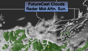
Sunday will be start off with some sun but clouds will roll in by late morning. Showers are likely during the afternoon as low pressure develops just offshore ahead of an approaching cold front. It’ll be more seasonal for November’s debut.
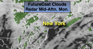
The front will move through Sunday night and bring with it the coldest airmass of the season so far on a gusty wind for Monday. A mix of sun and clouds is expected.
Chilled sunshine is in the forecast for Tuesday as high pressure moves in. Wednesday will be more seasonal as high pressure slips to the Southeast. The sun will continue to dominate.
Stay Tuned.
Keep it here for a no nonsense, no hype forecast.
Tonight:
Clear and cold. Lows around 35º in the City, the 20s inland. North wind at 5-10mph.
Halloween:
Sunny and chilly. Highs in the upper 40s. Northeast to Southeast winds at 5mph.
Sunday:
Early sun will give way to clouds and afternoon showers. Highs in the mid 50s.
Monday:
Partly Sunny, windy and cold. Highs only in the mid 40s.
Tuesday:
Mostly Sunny. Chilly. Highs in the upper 40s.
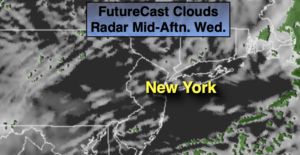
Wednesday:
Sunny and seasonal. Highs in the mid 50s.