Clouds & Sun Presidents’ Day. Mild…

Synopsis:

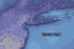
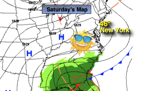
Presidents’ Day temperatures will reach early Spring readings once again as a weakening cool front approaches. The day will start with plenty of clouds but the sun will make a visit during the afternoon. Tuesday will be no different with above average readings. Scattered showers are in the forecast for the second half of the day as a disturbance to the North skirts our region.

A storm will develop over the mid-section of the country for the second half of the week. The track of the low will (like all its predecessors) move well to our North and West. This is a no snow solution. A warm front associated with the storm will move our way later Wednesday with afternoon showers a bit of sleet may mix in, especially North and West. Morning showers on Thursday should give way to the possibility of some sun, especially South and West. It now looks like the warm front will not swing through the region, meaning the 60s won’t pay a visit.

A gusty Northwest wind will develop around a deepening storm South of Nova Scotia on Friday. A mix of sun and clouds are expected with readings a few degrees above average.

Stay tuned.

Keep it here for a no hype, no nonsense forecast.

Presidents’ Day:

Clouds with some sun, mild. High in the mid 50s. West winds at 8-12mph.

Tonight:

Mostly cloudy. Scattered showers. Lows in the lower 40s in the City, the upper 20s and 30s inland. Northwest to Northeast winds at 5-10mph.
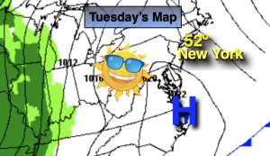
Tuesday:

Mainly cloudy with scattered showers in the afternoon. High in the upper 40s.
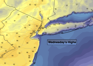
Wednesday:

Any morning sun giving way to thickening clouds and afternoon showers. Some sleet possible for the Northern half of the tri-state area. Cooler. High in the lower 40s, 30s inland.

Thursday:

Morning showers, otherwise mostly cloudy. High in the 40s.

Friday:

Partly sunny. Breezy. High in the 40s.

Milder Half of the Weekend…

Synopsis:

The short-lived chill has departed the area. High pressure will now become our mild weather maker as it moves offshore and the warmer return flow greet us for the second half of the weekend. A mix of sun and clouds is expected for Sunday with readings five to seven degrees above the average high of the lower 40s.

On Presidents’ Day temperatures will once again reach early Spring readings ahead of an approaching weakening cool front under as mix of sun and clouds. Tuesday will be no different with above average readings continuing with a chance of afternoon showers as a weak disturbance to the North skirts our region.

A storm will develop over the mid-section of the country for the second half of the week. The track of the low will (like all its predecessors) move well to our North and West. This is a warm solution. A warm front associated with the storm will move our way later Wednesday with rain. Morning showers on Thursday should give way to a some sun with mild readings.

Stay tuned.

Keep it here for a no hype, no nonsense forecast.

Sunday:

Partly sunny, mild. High around 50º. South winds at 8-12mph.

Tonight:

Mostly clear, milder than recent nights. Lows in the mid 40s in the City, the 30ss inland. Southwest winds at 5mph.

Presidents’ Day:

Partly sunny, mild. High in the mid 50s.

Tuesday:

More clouds than sun. Chance of afternoon showers. High in the upper 40s to lower 50s.

Wednesday:

Any morning sun giving way to thickening clouds and afternoon rain. Cooler. High in the lower 40s.

Thursday:

Morning showers giving way to some afternoon sun. Milder. High in the 50s.

More Like February – Minus the Snow…

Synopsis:

Saturday we’ll finally contend with near seasonable readings for daytime highs as cooler high pressure takes hold. The chill won’t last as the high move offshore and the mild return flow greet us for the second half of the weekend. Both days will feature mainly sunny skies.

On Presidents’ Day temperatures will once again reach early Spring readings ahead of an approaching cold front under as mix of sun and clouds. Tuesday will be no different with above average readings continuing with a chance of afternoon showers as a weak disturbance to the North skirts our region.

It’ll be a midweek delight with mostly sunny and mild conditions Wednesday as a ridge of high pressure works into the region.

Stay tuned.

Keep it here for a no hype, no nonsense forecast.

Saturday:

Sunny. More seasonable. Highs in the lower to mid 40s. Northwest to West winds at 8-12mph.

Tonight:

Clear. Lows in the mid 30s in the City, the upper teens and 20s inland. Southwest winds at 5mph.

Sunday:

Partly sunny, mild. High around 50º.

Presidents’ Day:

Partly sunny, mild. High in the mid 50s.

Tuesday:

More clouds than sun. Chance of afternoon showers. High in the upper 40s to lower 50s.

Wednesday:

Mostly sunny Mild. High in the lower 50s.

April-Like to Start Friday. Showers to Cooler PM…

Synopsis:

Low pressure will move will into extreme Northern New England today. A cold front associated with the storm will sweep through the our region during the midday hours. Morning highs will be Spring-like, then drop during the day. This will be the third consecutive day with readings above 60º for New York City. 70º was the high on Thursday. Simply amazing for February. By days end, most of the region will have readings drop into the 40s under the return of a bit of sun.

Typical Winter conditions will make a brief visit tonight. All readings will be below freezing with a gusty wind under starlit skies. Something we haven’t experienced in weeks.

Saturday we’ll finally contend with seasonable readings for daytime highs as cooler high pressure takes hold. The chill won’t last as the high move offshore and the mild return flow greet us for the second half of the weekend. Both days will feature mainly sunny skies.

On Presidents’ Day temperatures will once again reach early Spring readings ahead of an approaching cold front under as mix of sun and clouds. Tuesday will be no different with above average readings continuing.

Stay tuned.

Keep it here for a no hype, no nonsense forecast.

Friday:

Morning areas rain will give way to some mid to late afternoon sun. Warm to start. Temps will drop during the day.  Becoming windy. AM highs in the 50s & 60s falling to the upper 40s by late day. Southwest to Northwest winds at 15-25mph with gusts to 35mph.

Tonight:

Clear, windy and much colder. Lows in the mid 20s in the City, around 20º inland. Northwest winds at 15-25mph with gusts to 35mph.

Saturday:

Sunny. Seasonable. High in the lower 40s.

Sunday:

Partly sunny, mild. High around 50º.

Presidents’ Day:

Partly sunny, mild. High in the mid 50s.

Tuesday:

Partly sunny. High in the upper 40s.

Sun to PM Showers Thursday. Balmy…

Synopsis:

There will be no change in our stretch of Spring-like readings through Friday. Temperatures will be fifteen to twenty five degrees above the average high of the lower 40s. An April feel will continue as a strong Southwest flow continues around a Western Atlantic high.

A storm will develop over the Southern plains this morning. Any morning sun will give way to afternoon clouds. A warm front will push through our region during the afternoon with showers or even a quick period of rain. It’ll be balmy.

The low will move to Montreal, Canada by Friday morning. A cold front will sweep through the region at this time with another period of rain. Morning highs will be Spring-like, then drop during the day.

Saturday we’ll finally experience seasonable readings with highs in the lower 40s as cooler high pressure takes hold. The chill won’t last as the high move offshore and the mild return flow greet us for the second half of the weekend. Both days will feature mainly sunny skies.

On Presidents’ Day temperatures will once again reach early Spring readings ahead of an approaching cold front.

Stay tuned.

Keep it here for a no hype, no nonsense forecast.

Thursday:

Sun will give way to clouds. Warm. Scattered showers or a quick period of rain.  Highs in the mid 60s. Cooler over Eastern areas. West to South winds at 5-10mph.

Tonight:

Mostly cloudy. A spotty shower possible. Very mild. Lows in the mid 50s along the urban corridor, the 40s inland. These readings are ten to fifteen degrees above the average high for the date! Amazing. Southeast toSouthwest winds at 5-10mph.

Friday:

Morning rain to mid to late afternoon sun. Warm to start. Temps will drop during the day.  AM highs in the lower 60s falling to the upper 40s by late day.

Saturday:

Sunny. Seasonable. High in the lower 40s.

Sunday:

Partly sunny, mild. High around 50º.

Presidents’ Day:

Partly sunny, mild. High in the mid 50s.

Clouds to Sun. April Feel Wednesday…

Synopsis:

There will be no change in our stretch of Spring-like readings through Friday. Readings will be ten to twenty degrees above the average high. An April feel will greet us as a strong Southwest flow develops around a Western Atlantic high.

Today will begin with more clouds than sun but the sun will win the battle soon after. It be very warm but no where near the record high of 73º.

A storm will develop over the Southern plains Thursday morning. It’s warm front will push through our region during the day with scattered showers. It’ll be balmy. The low will move to Montreal, Canada by Friday morning. A cold front will sweep through the region at this time with a period of rain. Morning highs will be Spring-like, then drop during the day.

Saturday we’ll finally experience seasonable readings with highs in the lower 40s as cooler high pressure takes hold. The chill won’t last as the high move offshore and the mild return flow greet us for the second half of the weekend.

Stay tuned.

Keep it here for a no hype, no nonsense forecast.

Wednesday:

Clouds to sun. Warm and breezy. Highs in the lower to mid 60s. Cooler over Long Island and the immediate coast. South winds at 8-15mph with gusts to 30mph.

Tonight:

Partly cloudy. Very mild. Lows around 50º along the urban corridor, the 40s inland. Southwest winds at 5-10mph.

Thursday:

More clouds than sun. Warm. Scattered showers.  Highs in the lower 60s.

Friday:

Morning rain to sun. Warm to start. Temps will drop during the day.  AM highs in the lower 60s.

Saturday:

Sunny. Seasonable. High in the lower 40s.

Sunday:

Partly sunny, mild. High around 50º.

Bright, Mild Tuesday…

Synopsis:

There will be no change in our stretch of Spring-like readings through Friday. Readings will be ten to twenty degrees above the average high. An April feel will greet us once again (by midweek), as a strong Southwest flow develops around a Western Atlantic high. Until this time skies will be mainly sunny.

A storm will develop over the Southern plains Thursday morning. It’s warm front will push through our region during the day with scattered showers. It’ll be balmy. The low will move to Montreal, Canada by Friday morning. A cold front will sweep through the region at this time with a period of rain. Morning highs will be Spring-like, then drop during the day.

Saturday we’ll finally experience seasonable readings with highs in the lower 40s as cooler high pressure takes hold.

Stay tuned.

Keep it here for a no hype, no nonsense forecast.

Tuesday:

Sunny and mild with winds diminishing. Highs in the lower 50s. Northwest winds at 10-20mph during the morning, diminishing to 5-10mph during the afternoon.

Tonight:

Clear to partly cloudy. Lows in the mid 40s along the urban corridor, the 30s inland. Light Southeast winds.

Wednesday:

Partly sunny. Very mild. Highs around 60º.

Thursday:

More clouds than sun. Warm. Scattered showers.  Highs in the lower 60s.

Friday:

Morning rain to sun. Warm to start. Temps will drop during the day.  AM highs in the lower 60s.

Saturday:

Sunny. Seasonable. High in the lower 40s.

Sun is Back. Mild…

Synopsis:

A storm will move off the New England coast today with high pressure building over the Ohio Valley. Skies will be  sunny and it’ll be mild.

There will be no change in our stretch of above average temperatures for the upcoming week. Readings will be ten to twenty degrees above the average high. An April feel will greet us once again as a strong Southwest flow develops around a Western Atlantic high.

A storm will develop over the Southern plains Thursday morning. It’s warm front will push through our region during the day with spotty showers. It’ll be balmy. The low will move to Montreal, Canada by Friday morning. A cold front will sweep through the region at this time with a period of rain. Morning highs will be Spring-like, then drop during the day.

The jet stream, the river of air that guides our weather systems has predominately been out of the Pacific-a mild result. The polar jet that frequently visits our region during the Winter has been M.I.A. so far.

Stay tuned.

Keep it here for a no hype, no nonsense forecast.

Monday:

Mostly sunny. Mild. Highs in the lower 50s. North to West winds at 5-15mph.

Tonight:

Clear and breezy, Lows around 40º along the urban corridor, the 20s & 30s inland. Northwest winds at 10-20mph with gusts to 30ph.

Tuesday:

Sunny and mild. Highs in the lower 50s.

Wednesday:

Partly sunny. Very mild. Highs around 60º.

Thursday:

More clouds than sun.  Warm. Chance of  an spotty showers.  Highs in the lower 60s.

Friday:

Morning rain to sun. Warm to start. Temps will drop during the day.  AM highs in the lower 60s

Increasing, Thickening Clouds Sunday…

Synopsis:

Low pressure will develop in the Carolina’s. Any morning sun North will give way to increasing afternoon clouds in all areas for Super Bowl Sunday.

The storm will move up and off the coast tonight into Monday morning. Coastal rain is in the forecast. Inland it will remain dry. The rain will be out of the region by Monday mid morning out East. Clouds will give way to mainly sunny skies and yep, mild readings will stick around.

No change in our stretch of mild conditions for Tuesday through Thursday. Readings will be ten to twenty degrees above the average high. An April feel will greet us once again as a strong Southwest flow develops around a Western Atlantic high.

The jet stream, the river of air that guides our weather systems has predominately been out of the Pacific-a mild result. The polar jet that frequently visits our region during the Winter has been M.I.A.

Stay tuned.

Keep it here for a no hype, no nonsense forecast.

Sunday:

Any sun North giving way to increasing and thickening afternoon clouds in all areas. Highs in the upper 40s to around 50º. Southwest to East winds at 5mph.

Tonight:

Coastal rain in spots. Cloudy elsewhere. Lows in the upper 30s along the urban corridor, the 20s inland. Northeast to North winds at 5-10mph.

Monday:

Any early morning clouds and areas of rain at the coast, otherwise becoming mostly sunny. Highs around 50º.

Tuesday:

Sunny and mild. Highs in the lower 50s.

Wednesday:

Partly sunny. Very mild. Highs in the upper 50s to lower 60s .

Thursday:

Partly sunny. Warm. Chance of  an isolates shower.  Highs in the lower 60s

Sunny, Tolerable Temps Saturday…

Synopsis:

High pressure will move in for Saturday. Temperatures will be tolerable under a sunny sky. Readings will be around five degrees above the average high of 41º.

On Sunday, low pressure will develop in the Carolina’s. Morning sun will give way to increasing afternoon clouds for Super Bowl Sunday.

The storm will move up and off the coast Sunday night into Monday morning. Coastal rain is in the forecast. How far inland the rain pushes is a question that needs to be answered. Whatever happens with the storm’s specific track, the precipitation threat will be out of the region by Monday late morning. Clouds will give way to mainly sunny skies by afternoon and yep, mild readings will stick around.

No change in our stretch of mild conditions for Tuesday and Wednesday. Readings will be ten to fifteen degrees above the average high.

The jet stream, the river of air that guides our weather systems has predominately been out of the Pacific-a mild result. The polar jet that frequently visits our region during the Winter has been M.I.A.

Stay tuned.

Keep it here for a no hype, no nonsense forecast.

Saturday:

Sunny, cooler. Highs in the mid 40s. West winds at 10-15mph during the morning and diminishing.

Tonight:

Clear. Lows in the mid 30s along the urban corridor, the upper teens and 20s inland. Light Southwest winds.

Sunday:

Sun giving way to increasing and thickening afternoon clouds. Highs around 50º

Monday:

Any early morning clouds and rain at the coast, otherwise becoming mostly sunny. Highs around 50º.

Tuesday:

Sunny and mild. Highs in the lower 50s.

Wednesday:

Partly sunny. Very mild. Highs in the upper 50s.