Synopsis:
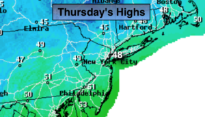
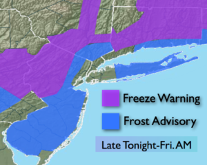
Cold high pressure moving into our area will result in well below average temperatures through Friday morning. Readings today may not get out of the 40s for highs! Freeze Warnings and Frost Advisories have been posted for tonight. If you want your potted plants alive in these areas, either cover them up or bring them in. If not they’ll be wilted by morning.
Friday will be bright and chilly as high pressure dominates.
Spotty showers are possible Saturday morning otherwise skies will be partly sunny. Another significant cold front will move our way Saturday night. Sunday will be most likely the coldest day of the season so far with gusty winds. At least it won’t be raining.
It looks like Autumn wants to stick around.
You know where to find a no hype, no nonsense forecast.
Today:
Partly sunny, breezy and much colder. Highs in the upper 40s. Northwest winds at 10-20mph.
Tonight:
Clear and cold. Lows in the lower 40s in the City, the upper 20s to near freezing inland. Northwest to West winds less than 5mph.
Friday:
Mostly sunny. Highs in the upper 50s.
Saturday:
Spotty morning showers otherwise partly sunny. Highs around 60º.
Sunday:
Partly sunny, windy and cold. Highs in the upper 40s.
Monday:
Mostly sunny and very cool. Highs in the lower 50s.
Keep it here for a no nonsense, no hype forecast.