
Synopsis:
The weekend should be mainly dry as high pressure from the West begins to take hold under a mix of sun and clouds. An isolated afternoon storm is possible today. It’ll be much less humid by Sunday with seasonal readings and mainly sunny skies. Sunday will be spectacular.
Looking ahead, another Bermuda high will begin to setup shop mid to late week with heat and humidity returning.
Stay tuned.
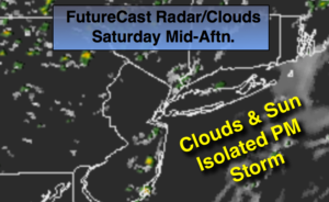
Saturday:
Areas of morning clouds and fog, otherwise becoming partly sunny. An isolated afternoon storm is possible. Most areas will remain dry. Highs in the mid 80s. South wind at 5-10mph.
Tonight:
Mostly clear, cooler and more comfortable. Lows around 70º in the City, near 60º inland. Northwest winds under 5mph.
Sunday:
Sunny. Low humidity. Highs in the mid 80s.
Monday:
Mostly sunny. Highs in the mid 80s.
Tuesday:
Sun and clouds. Humid. Scattered showers are possible. Highs in the lower 80s.
Wednesday:
Mostly cloudy. Humid. Scattered showers and storms. Highs in the mid 80s.
Keep it here for a no nonsense, no hype forecast.