Synopsis:
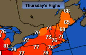
The remainder of the week looks pleasant with the sun dominating as high pressure takes control. Readings will start off just below average for today ( the average high is 76º) then work to above average levels by Friday.
We may have to dodge some showers for this weekend as a stationary front sits over the region. Although some of the latest computer guidance has the rain completely missing the area. I will wait for another model run to determine if this trend could become a reality. The greatest threat of showers and thunderstorms is Saturday and Saturday night. It’s too early to pinpoint specifics with timing on Saturday. At this time, it doesn’t look like a washout. We should squeak out a dry Sunday as the front pushes farther South.
Stay tuned.
Today:
Clouds giving way to mostly sunny skies. Highs in the lower to mid 70s. South wind at 5-10mph.
Tonight:
Mostly clear. Lows in the lower 60s in City, the 50s inland. South to Southwest winds at less than 5mph.
Friday:
Mostly sunny, warmer. Highs in the lower 80s.
Saturday:
Mostly cloudy, warm and humid. Scattered showers and storms. Highs around 80º.
Sunday:
Morning clouds will give way to partly sunny skies. It’ll be much less humid. Highs in the mid 70s.
Monday:
Partly sunny. Highs around 80º.
Keep it here for a no nonsense, no hype forecast.