Synopsis:
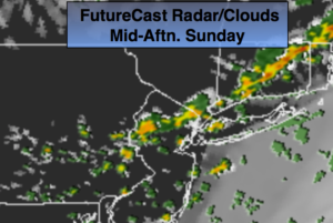
Today will be much warmer than recent days. After morning clouds and early spotty showers, the sun will return. A cool front will approach during the afternoon with scattered thunderstorms. Again, to highlight there will be several hours of sun. It will not be a washout.
High pressure will work in on Monday. The sun will dominate with readings around 80º. A gorgeous day is on tap.
Showers will return for Tuesday with a weak low passing through.
Looking down the pike decent weather looks to be in our future midweek into the start of the Memorial Day Weekend. Did I just write Memorial Day Weekend? Wow!
Stay tuned.
Today:
Clouds and early scattered morning showers will give way to partly sunny skies. Scattered thunderstorms are possible by mid-afternoon. Much warmer. Highs in the upper 70s. Southwest to Northwest winds at 8-12mph.
Tonight:
Clear and comfortable. Lows around 60º in the City, the 50s inland. Northwest wind at 5-10mph.
Monday:
Mostly sunny. Highs near 80º.
Tuesday:
Mostly cloudy. Scattered showers. Highs in the lower 70s.
Wednesday:
Partly sunny. Highs in the mid to upper 70s.
Thursday:
Sunny. Highs in the mid to upper 70s.
Keep it here for a no nonsense, no hype forecast.