Synopsis:
The sun will return today, but it will be windy and chilly as low pressure over Eastern Canada continues to influence our weather. The weekend looks mainly sunny and cool and high pressure works in. Readings will be below average by a few degrees. The average high is 63º for the date.
It looks like below average temperatures will continue for some time as the Northern branch of the jet stream remains close to our latitude. We’ll also be watching a storm off the Southeast coast and it’s possible affects on our area midweek. Yep, this Spring is tough to take.
Stay tuned.
Today:
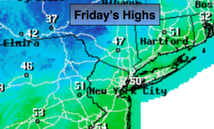
Partly sunny. Windy. Highs around 50º. Northwest winds at 15-25mph with gusts to 30mph.
Tonight:
Clear and cold. Lows in the upper 30s in the City,near 30º inland. Northwest winds diminishing to 5-10mph.
Saturday:
Mostly sunny. Highs in the mid to upper 50s.
Sunday:
Sunny. Highs in the upper 50s.
Monday:
Mostly sunny. Highs in the lower 60s.
Tuesday:
Sun will give way to increasing clouds. Highs in the lower 60s.
Keep it here for a no nonsense, no hype forecast.