Synopsis:
Unfortunately, the weather still doesn’t want to cooperate for the Yankees home opener today as a warm front will move toward the area with periods of rain developing from midday on. The game is scheduled for 4pm.
A very active early April pattern will be with us for the next week. Rapidly changing weather conditions are expected with a roller coaster ride in temperatures.
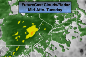
Once the warm front moves North on Wednesday readings should soar well into the 60s to near 70º. It will become windy ahead and behind the cold front that will be moving in Wednesday afternoon. Thunderstorms may accompany the front.
Much colder readings will greet us on Thursday with readings only rising into the 40s.
There has been chatter about a storm for this weekend. At this time, the latest computer models have the system offshore not affecting us. I am not completely discounting the threat of the low affecting us.
Stay tuned.
Today:
Cloudy with periods of rain developing from midday on. Highs in the mid to upper 40s. East winds at 8-12mph.
Tonight:
Cloudy with spotty showers and areas of fog. Temperatures will actually rise through the 40s and into the 50s late. East winds becoming Southwest at 5-10mph.
Wednesday:
Mostly cloudy with scattered showers and possibly a thunderstorm. Windy and warm. Highs in the mid 60s to around 70º to the South.
Thursday:
Partly sunny and colder. Highs in the mid 40s.
Friday:
Partly sunny. More seasonal. Highs in the lower to mid 50s.
Saturday:
Partly sunny. Chilly. Highs in the mid 40s.
Keep it here for a no nonsense, no hype forecast.