Synopsis:
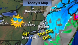
The Spring snowstorm that gave many area between 5″-15″+ of snow is slowly pulling off the New England coast. Any areas of light snow early this morning will move offshore. Clouds will give way to some sun. It’s Spring (without a cold airmass moving in) temperatures will pop into the 40s today-snowmelt for sure.
High pressure will nose in from Canada and keep the chill around despite the sunshine into the weekend. This high should suppress a storm moving out of the Midwest to the South on Sunday.
Stay tuned.
Today:
Morning areas of snow East, otherwise, clouds giving way to some sun. Breezy. Highs in the 40s. Northwest winds at 10-20mph with higher gusts.
Tonight:
Partly cloudy. Lows around freezing in the City, the 20s inland. There will be a refreeze of the slush, please use caution. Northwest 5-10mph.
Friday:
Partly sunny, Breezy. Highs in the mid 40s.
Saturday:
Partly sunny. Highs in the mid 40s.
Sunday:
Partly sunny. Highs in the mid 40s.
Monday:
Partly sunny. Highs in the mid 40s.
Keep it here for a no nonsense, no hype forecast.