Synopsis:
A persistent Northwesterly flow will continue resulting in colder than average temperatures right through the weekend. The culprit, a stationary storm in Eastern Canada and high pressure nosing in from central Canada. A mix of sun and clouds is expected through Sunday. Today will blustery with highs only in the upper 30s. The wind will be like a slap in the face with gusts well over 30mph. The weekend will be more tranquil.
A low may affect the area Tuesday into Wednesday. At this time it is too early to determine how much rain and or snow will fall. The models do have an area of low pressure on the map over the Eastern states, but where does it go? Where does the secondary redevelopment occur? These questions needed to be answered. Many days to watch this unfold.
Stay tuned.
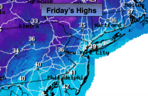
Today:
Partly sunny, windy and cold. Highs in the upper 30s. Northwest winds at 15-30mph with higher gusts.
Tonight:
Partly cloudy. Breezy. Lows near 30º in the City, near 20º inland. Northwest winds diminishing to 10-15mph after midnight.
Saturday:
Partly sunny. Highs in the lower to mid 40s.
Sunday:
Sunny. Highs in the mid 40s.
Monday:
Mostly sunny. Highs in the mid 40s.
Tuesday:
Thickening clouds. Chance of rain and or wet snow. Highs in the upper 30s.
Keep it here for a no nonsense, no hype forecast.