Synopsis:
February’s finale will be a bright, mild one. High pressure moving off the coast will provide a mild southwest wind and bright conditions today.
March will come in like a lion. A storm will develop over the midwest on Thursday and throw a warm front into the area. Rain will develop during the afternoon hours and continue through the night. The storm will transfer its energy to a rapidly developing secondary storm just off the coast of NJ. The exact location of this second storm and how it moves will determine our weather conditons for Friday. Questions that need to be answered: 1. How much additional rain and possibly wet snow (inland) will fall? The latest computer models have the storm bombing off or over Eastern Long Island. The heaviest rain now looks to fall Thursday night into Friday morning. The storm looks to do a loop de loop. There maybe a break in the precipitation with lighter rain or drizzle with a large dry slot over much of the area for a few hours. Then the precipitation works back in on the backside of the storm. 2.How serious will the coastal flooding will occur, and how strong will the winds become ?
The thinking is rain with some wet snow mixed in North and West will occur. Accumulations maybe hard to come by with much of the precipitation falling during the day, but if the snow falls hard enough an accumulation can occur inland. The March sun angle is higher than it was in the dead of Winter and it’ll be just marginally cold enough for some wet snow. But, there is a low potential for the rain to completely go over to wet snow inland. If this occurs, an accumulation is likely. These details need to be ironed as new computer guidance comes in. Please check in frequently as this could become a rapidly deteriorating situation on Friday.
The storm finally pulls off our coastline to the Southeast Friday night, ending the precipitation but the winds will be strong. Gusting to 50mph at times.
Saturday will be very windy with early snow showers giving way to clouds and sun. Sunday the winds will ease some.
Stay tuned
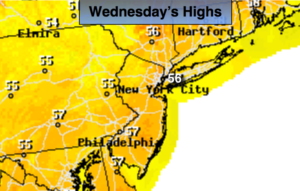
Today:
Mostly sunny. Mild. Highs in the mid 50s. Southwest winds at 5mph.
Tonight:
Thickening clouds. Lows in the mid 40s in the City, the 30s to around 40º inland. Southwest winds at 5mph.
Thursday:
Becoming cloudy. Rain likely during the afternoon. Highs in the lower to mid 50s.
Friday:
A chance of rain. A mix of rain and wet snow is possible inland. There is a low potential for the rain to completely go over to wet snow inland. There maybe a lull in the precipitation for a few hours. Becoming windy. Highs in the 40s, 30s inland.
Saturday:
Morning scattered snow showers otherwise a mix of clouds and some sun. Windy. Highs in the mid 40s.
Sunday:
Mostly sunny. The winds will ease. Highs in the mid 40s.
Keep it here for a no nonsense, no hype forecast.