Synopsis:
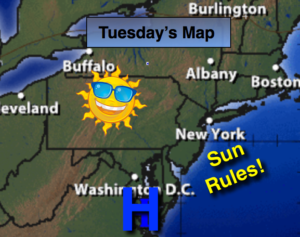
Fine late February weather will be us through Wednesday with high pressure dominating. This will result in sunny skies and mild readings.
March will come in like a lion. A storm will develop over the midwest on Thursday and throw a warm front into the area. Rain will develop during the afternoon hours and continue through the night. The storm will transfer its energy to a rapidly developing secondary storm just off the coast of NJ. The exact location of this second storm and how it moves will determine our weather conditons for Friday. Questions that need to be answered: How much additional rain and possibly wet snow will fall inland? How much coastal flooding if any will occur, and how strong will the winds become? The latest computer models have the storm developing a bit farther South. The thinking is rain with some wet snow mixed in North and West will occur. Accumulations maybe hard to come by with much of the precipitation falling during the day. The March sun angle is higher than it was in the dead of Winter and it’ll be just marginally cold enough for some wet snow. These details need to be ironed as new computer guidance comes in.
Stay tuned
Today:
Sunny. Highs in the mid 50s. Northwest to Southwest winds at 5-10mph.
Tonight:
Clear. Lows around 40º in the City, the upper 20s and 30s inland. Southwest winds at 5mph.
Wednesday:
Mostly sunny. Highs in the mid 50s.
Thursday:
Becoming cloudy. Rain likely during the afternoon. Highs around 50º.
Friday:
A chance of rain. Some wet snow may mix in North and West at times. Becoming windy. Highs in the 40s.
Saturday:
Clouds and some sun. Windy. Highs in the 40s.
Keep it here for a no nonsense, no hype forecast.