Synopsis:
A change in the weather pattern will occur today through Wednesday with high pressure dominating. This will result in sunny skies and mild readings for later February.
March will come in like a lion. A storm will develop over the midwest on Thursday and throw a warm front into the area. Rain will develop during the morning hours and continue throughout the day. The storm will transfer its energy to a rapidly developing secondary storm very close to the area. The exact location of this second storm and how it moves will determine our weather conditons for Friday. Questions that need to be answered: How much additional rain and possibly wet snow will fall inland? How much coastal flooding if any will occur, and how strong will the winds become? If the storm develops farther to the South the three parameters mentioned will be more severe. If the storm develops farther to the North and East the conditions in our area won’t be harsh. These details need to be ironed out over the next couple of days.
Stay tuned
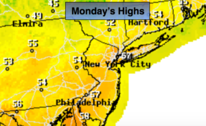
Today:
It’ll finally dry out. Clouds and sun will give way to mostly sunny skies. Mild. Highs in the mid to upper 50s.
Tonight:
Clear. Lows around 40º in the City, the 20s and 30s inland. Northwest winds at 5mph.
Tuesday:
Sunny. Highs in the lower to mid 50s.
Wednesday:
Mostly sunny. Highs in the mid 50s.
Thursday:
Rain likely. Highs in the lower 50s.
Friday:
A chance of rain. Some wet snow may mix in North and West at times. Highs in the 40s.
Keep it here for a no nonsense, no hype forecast.