Synopsis:
The next and last in a series of low pressure systems will work through the region on Sunday. Areas of rain, drizzle and fog is expected overnight. A round of steadier and heavier rain is likely on Sunday morning as a warm front and low pressure system affect the region. The rain will taper off during the afternoon but clouds should hang tough as the system moves to our North.
A change in the weather pattern will occur by early next week with high pressure dominating. This will result in sunny skies.
There has been chatter about an early March storm. All of the computer models do have a storm on the map anywhere between March 1st through March 3rd. The placement and strength of this system is all over the place as you would expect this many days out. Many players have to come into place for this to an end as a significant snow event. It will definitely start off as rain on Thursday.
Stay tuned
Tonight:
Cloudy with areas of light rain, drizzle and fog. Lows around 40º in the City, the upper 30s inland. Northeast winds at 5-10mph.
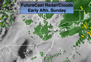
Sunday:
A steady rain during the morning will turn taper off during the afternoon. Clouds will remain. Highs in the lower 50s. East to Northeast winds at 8-12mph.
Monday:
It’ll finally dry out. Mostly sunny skies are anticipated with highs in the lower to mid 50s.
Tuesday:
Sunny. Highs in the lower to mid 50s.
Wednesday:
Mostly sunny. Highs in the mid 50s.
Thursday:
Rain likely. Highs in the lower 50s.
Keep it here for a no nonsense, no hype forecast.