Synopsis:
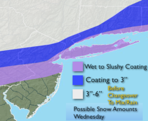
An area of low pressure will develop over the Tennessee Valley and track very close our area by later today. This will result in a period of snow for the Northern 1/2 of the tri-state area beginning by dawn to mid-morning. Farther to the South mainly rain will fall. Because the low is so close to our area and cold high pressure is moving off the New England coast the snow will change to rain for most of the region. Before this changeover an accumulating snow is likely North and West of the City. Sleet and freezing rain is likely North and West before the changeover to rain. Snow amounts are above. The rain will end this evening.
Dry, tranquil conditions are expected for the end of the week as high pressure moves toward the East coast.
Stay tuned.
Today:
AM Snow/Mix to rain. Highs in the mid 30s to lower 40s. Northeast winds at 5-10mph.
Tonight:
Rain ends this evening, becoming mostly clear. Lows in the upper 20s in the city, the teens & 20s inland. Northwest winds increasing to 15-25mph.
Thursday:
Mostly sunny. Highs in the mid 30s.
Friday:
Partly sunny. Highs in the mid 30s.
Saturday:
Mostly cloudy. Highs in the mid 40s.
Sunday:
Periods of rain. Highs in the mid 40s.
Keep it here for a no nonsense, no hype forecast.