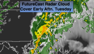
Synopsis:
A warm front moving through the area this morning will be followed by a cold front sweeping through later this afternoon. The result will be areas of fog with periods of rain. The rain will be locally heavy at times (FutureCast Radar above shows the heavy rain). It will be warm. The sun will most likely make an appearance once the front clears the coast later in the afternoon. It’ll feel more like Spring.
More seasonal temperatures are expected for the later half of the workweek as colder high pressure moves in from Canada.
Looking down the pike no snowstorms are on the map at least through the next seven days.
Stay tuned.
Today:
Rain through early afternoon. Local downpours. Some afternoon sun. Warm and breezy. Highs in the mid 50s. South to West winds at 10-20mph with gusts to 30mph.
Tonight:
Clearing skies. Lows in 30s in the City, near or below freezing inland. Northwest winds 10-20mph with gusts to 30mph.
Wednesday:
Partly sunny. Colder. Highs around 40º.
Thursday:
Mostly sunny. Cold. Highs in the mid 30s.
Friday:
Sunny. Seasonal. Highs in the mid to upper 30s.
Saturday:
Mostly sunny. Milder. Highs in the mid to upper 40s.
Keep it here for a no nonsense, no hype forecast.