Synopsis:
The Arctic high pressure responsible for the coldest night of the season so far will provide a mostly sunny sky despite the numbing cold today. Thankfully the winds will be much lighter.
There is light at the end of the tunnel-temperatures will rise above freezing next week. This will be the first time the mercury has been above the freezing mark since Christmas Day.
A bit of light snow or a mix will fall Monday afternoon as a weak system moves in from the West. It will only last a couple of hours. This will not add up to much in the way of accumulation.
A January thaw will be well received as readings go well above average by Thursday and Friday as a deep Southerly flow develops.
Stay tuned.
Today:
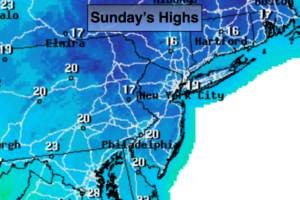
Mostly sunny and cold. Highs in the upper teens to lower 20s. Northwest to Southwest 5-10mph.
Tonight:
Becoming mostly cloudy. Not as cold with steady temperatures along the coast. Lows in the lower 20s in the City, the teens and single digits inland. Southwest winds at 5-10mph.
Monday:
Mostly cloudy with a chance of afternoon light snow or a mix. This will only last a couple of hours Highs in the lower to mid 30s.
Tuesday:
Partly sunny. Highs in the upper 30s to around 40º.
Wednesday:
Partly sunny. Highs in the mid 30s.
Thursday:
Partly sunny. Warmer. Highs in the upper 40s.
Keep it here for a no nonsense, no hype forecast.