Synopsis:
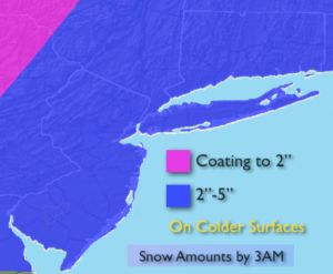
The first snowfall of the season will begin to wind down this evening and overnight East of the City. The majority of the region will pick up between 2″-5″ of snow.
Please use caution as the first snow is usually the most difficult to handle. Many are not used to driving and walking in these conditions.
A dry Northwest flow will be with us Sunday. The sun will return and it’ll be breezy and chilly.
The next system we have our eyes on is a system coming out of the Northwest. At this time, it looks like all of the mechanics to form a decent storm will happen too far North. But, if the storm develops farther South our area could receive “some snow”. There are still a few days to watch this one and I’m not writing it off. One thing is for sure the cold is set in stone. In fact, an Arctic blast will be with us on Wednesday. Temperatures will remain in the 20s.
Stay tuned.
Tonight:
Snow ends late evening to after midnight East. Lows around 30º in the City, 20s inland. Northwest wind will become West at 8-12mph.
Sunday:
Clouds and sun. Breezy. Highs in the upper 30s to around 40º. West wind at 10-20mph.
Monday:
Sun and clouds. Highs in the lower 40s.
Tuesday:
Mostly cloudy. A bit of light snow is possible in the morning. Highs in the upper 30s.
Wednesday:
Partly sunny, windy and brutally cold. Highs in the upper 20s. Wind chills 10º-15º.
Thursday:
Partly sunny, breezy and cold. Highs around freezing.
Keep it here for a no nonsense, no hype forecast.