Synopsis:
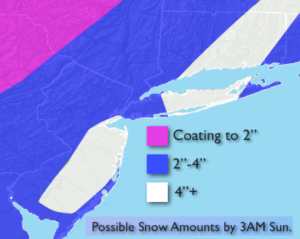
The first snowfall of the season is on the way. Snow will develop today South of the City around sunrise and overspread the tri-state area during the morning. Low pressure will work up and off the coast. The snow may mix with rain over Eastern Long Island. The steadiest and heaviest snow looks to occur Saturday afternoon before it tapers off during the evening. Above are the possible amounts. The heaviest snow looks to be concentrated over parts of central and Southern NJ and Long Island and CT.
Even though this won’t be a major snowfall please use caution as the first snow is usually the most difficult to handle. Many are not used to driving and walking in these conditions.
The storm will move away Saturday night and a cold wind will be with us Sunday under partly sunny skies.
The second unit of energy will come our way Tuesday. At this time, it looks like all of the mechanics to form a decent storm will happen too far North. But, if the storm develops farther South our area could receive “some snow”. There are still many days to watch this one and I’m not writing it off. One thing is for sure the cold is set in stone. In fact, an Arctic blast will be with us on Wednesday. Temperatures will remain in the 20s.
Stay tuned.
Today:
Snow developing during the morning and continuing throughout the day. Rain may mix with the snow over Eastern Long Island. Highs in the lower to mid 30s. North wind at 8-12mph.
Tonight:
Snow ends late evening to after midnight East. Lows around 30º in the City, 20s inland. Northwest wind will become West at 8-12mph.
Sunday:
Clouds and sun. Breezy. Highs in the upper 30s to around 40º.
Monday:
Sun and clouds. Highs in the upper 30s.
Tuesday:
Mostly cloudy. A bit of light snow is possible. Highs in the upper 30s.
Wednesday:
Partly sunny, windy and brutally cold. Highs in the upper 20s. Wind chills 10º-15º.
Keep it here for a no nonsense, no hype forecast.